Difference between revisions of "File:JF projects on occupied territory.jpg"
Hilary Aked (talk | contribs) (Above: screenshot of some of the Jerusalem Foundation's projects in and around the Old City from the interactive map on its website. Below: Map showing the Green Line indicating that all JF's projects to the east of this line are on illegally occupied ter) |
(No difference)
|
Latest revision as of 16:44, 10 September 2012
Above: screenshot of some of the Jerusalem Foundation's projects in and around the Old City from the interactive map on its website. Below: Map showing the Green Line indicating that all JF's projects to the east of this line are on illegally occupied territory. (Palestine Mapping Centre via JFJFP)
File history
Click on a date/time to view the file as it appeared at that time.
| Date/Time | Thumbnail | Dimensions | User | Comment | |
|---|---|---|---|---|---|
| current | 16:44, 10 September 2012 | 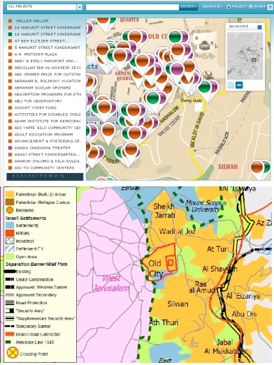 | 392 × 523 (113 KB) | Hilary Aked (talk | contribs) | Above: screenshot of some of the Jerusalem Foundation's projects in and around the Old City from the interactive map on its website. Below: Map showing the Green Line indicating that all JF's projects to the east of this line are on illegally occupied ter |
- You cannot overwrite this file.
File usage
The following page links to this file: